Chesapeake Bay Climate Adaptation Toolbox
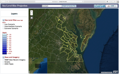
AdaptVA: Sea Level Rise Projection Viewer
Developed By: Virginia Institue of Marine Science (VIMS) Center for Coastal Resources Management (CCRM)
Summary: The AdaptVA Sea Level Rise Projection Viewer uses an interactive map to display sea level rise projections for coastal Virginia.
This easy-to-use tool provides three sea level rise scenarios (low, intermediate, and extreme), which can be viewed at 10-year increments from 1992 – 2100. Users may click through or automate the display to view 10-year intervals for each sea level rise scenario. This tool is intended for beginner users and does not require any specialized software or training.
Get This Tool: http://cmap2.vims.edu/SeaLevelRise_Depth/SLRDepth_revised4.html
Geographic Coverage
- Coastal Virginia
Tags
- Climate projections
- Grid based
- Regional level
- Computer application
- Interactive interface/map
- Compare scenarios/locations
Cost
- Free
Skill Level
- Low