Chesapeake Bay Climate Adaptation Toolbox
Hampton Roads Geospatial Exchange Online: Hampton Roads Sea Level Rise Planning Scenarios (Raster)
Developed By: Hampton Roads Planning District Commission (HRPDC), Hampton Roads Sanitation District (HRSD), and Hampton Roads Transportation Planning Organization (HRTPO)
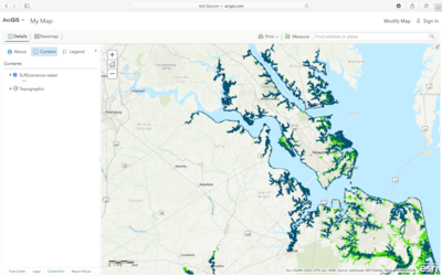
Summary: Part of Hampton Roads Geospatial Exchange Online, the Hampton Roads Sea Level Rise Planning Scenarios uses an interactive map to display sea level rise projections for Hampton Roads.
This easy-to-use tool provides three sea level rise scenarios: 1.5 feet above mean higher high water (MHHW: 2050), 3 feet above MHHW (2080), and 4.5 feet above MHHW (2100). The scenarios are based on the Hampton Roads Planning District Commission’s Sea Level Rise Planning and Policy Approach which uses information from National Atmospheric and Oceanic Administration’s “Mapping Coastal Inundation Primer.” Users may select to display each sea level rise scenario individually or simultaneously with the other two. Within each layer, users can find the distribution of inundated areas and low-lying areas vulnerable to ponding. The tool is intended for beginner users and does not require specialized software or training. More advanced users can upload their own data or access data through Esri online.
Get This Tool: https://www.hrgeo.org/maps/HRPDC-GIS::hampton-roads-sea-level-rise-planning-scenarios-raster/about
Geographic Coverage
- Chesapeake City, VA; Franklin City, VA; Gloucester County, VA; Hampton City, VA; Isle of Wight County, VA; James City County, VA; Newport News City, VA; Norfolk City, VA; Poquoson City, VA; Portsmouth City, VA; Smithfield, VA; Southampton County, VA; Suffolk City, VA; Surry County, VA; Virginia Beach City, VA; Williamsburg City, VA; York County, VA
Tags
- Climate projections
- Grid based
- Regional level
- Dataset
- Interactive interface/map
- Compare scenarios/locations
- Downloadable data
Cost
- Free
Skill Level
- Low