Chesapeake Bay Climate Adaptation Toolbox
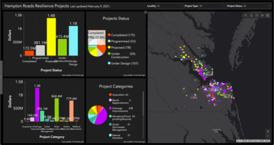
Hampton Roads Geospatial Exchange Online: Hampton Roads Resilience Projects Dashboard
Developed By: Hampton Roads Planning District Commission (HRPDC), Hampton Roads Sanitation District (HRSD), and Hampton Roads Transportation Planning Organization (HRTPO)
Summary: Part of the Hampton Roads Geospatial Exchange Online portal, this tool provides summary graphics and an interactive map to view current and proposed projects to improve resilience to flooding and coastal hazards in Hampton Roads, VA.
The Resilience Projects Dashboard allows users to view the cost, status, type, and location of relevant resilience projects within the region. Users can search for projects by locality, project type, and/or project status. The dashboard also includes an interactive map that displays the location and additional details of each project.
Get This Tool: https://www.arcgis.com/apps/opsdashboard/index.html#/271ff8ba589540f494fc1770712cfea3
Geographic Coverage
- Chesapeake City, VA; Franklin City, VA; Gloucester County, VA; Hampton City, VA; Isle of Wight County, VA; James City County, VA; Newport News City, VA; Norfolk City, VA; Poquoson City, VA; Portsmouth City, VA; Smithfield, VA; Southampton County, VA; Suffolk City, VA; Surry County, VA; Virginia Beach City, VA; Williamsburg City, VA; York County, VA
Tags
- Real-time/Current
- Jursidiction based
- County level
- Regional level
- Computer application
- Interactive interface/map
- Cost estimates
Cost
- Free
Skill Level
- Low