Chesapeake Bay Climate Adaptation Toolbox
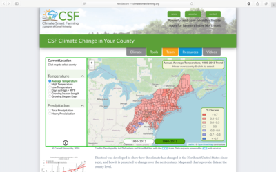
Climate Smart Farming: Climate Change in Your County
Developed By: Cornell University College of Agriculture and Life Sciences
Summary: Part of the Climate Smart Farming toolkit, the Climate Change in Your County tool allows users to view historic and projected future temperature and precipitation data within their county and region.
Through this easy-to-use tool, users can access an interactive map depicting regional changes in temperature and precipitation dating back to 1950. Within the map, users may display a variety of temperature and precipitation metrics such as shifts in growing season length or days with heavy precipitation. In addition to the regional map view, users may also select a specific county to view locality specific plots of past and future conditions. Future projections are provided for both a low (emissions peaking by 2040: RCP4.5) and high emissions (no mitigation: RCP8.5) scenario. Raw data from the tool is publicly available through the Applied Climate Information System. The tool is still being revised and users are encouraged to provide feedback to the developers.
Get This Tool: http://climatesmartfarming.org/tools/csf-county-climate-change/
Geographic Coverage
- Delaware; Maryland; New Jersey; New York; Pennsylvania
Tags
- Historical
- Climate projections
- Jursidiction based
- County level
- Computer application
- Interactive interface/map
- Compare scenarios/locations
- Downloadable results
Cost
- Free
Skill Level
- Low